
Inca Trail, Day One: A Modern Canterbury Tale!
(You may click on any photograph to pull up a much larger version of the image.)
January 20, 2010 CUZCO, PERU. The wake up calls were set for 4:30am, but I awoke a half hour earlier due to an anxious “body clock” that couldn’t wait to get on with this adventure! Llama Path would meet us downstairs in the lobby of the Hotel Monasterio with their Mercedes bus and our porter team at 5:00am for a drive to the Urubamba River town of Ollantaytambo in the heart of the Sacred Valley, where we would have breakfast.

Dave and Chris with our guide from Llama Path, Julian Perez, in the hotel lobby ready to board our small bus and begin the Inca Trail!
As we climbed the highway out of Cuzco that morning and crested the high plain surrounding the city, the countryside was lit with a beautiful pre-dawn grey light that made the green and brown colors of the fields and hills more vibrant and lush.

The countryside along the road to Ollantaytambo and the Sacred Valley, with a view of Lake Piuray in background.
The hour and a half ride to our first stop went smoothly and became much more dramatic as we approached the Sacred Valley, a huge gaping gash in the earth straight ahead and running absolutely perpendicular to our route. The opposite side of the deep valley was a mountain ridge that seemed to disappear in the clouds above, the near side was cut by the switch-back road we were following in our descent to the river town of Urubamba. There, we crossed the mighty river and turned northwest, following the Urubamba River toward Ollantaytambo. Shortly, we were in that ancient Inca river town where we turned up a hillside street to find a quaint restaurant used by Llama Path for their breakfast stops before starting each trek: the Restaurant El Watakay. High above us we saw our first glimpse of Inca ruins since Cuzco, clinging to the steep canyon walls. Excitement built as we ate our “American Breakfast” of scrambled eggs, ham and toast. It was hard to sit still; getting to the bus was our main focus, even as a much larger Llama Path group arrived to have their own “last breakfast” as we slipped out and into our bus.

Breakfast stop in Ollantaytambo

Watakay Restaurant courtyard and porters with red Llama Path gear.

Davison pointing out the guinea pig (cuy) pen at the Watakay Restaurant!

Lunch…or dinner…cuy anyone?
Thirty minutes later, we were disembarking the bus for the final time at the famous “Kilometro 82”, where the road runs out at a sleepy little hamlet called Piskacucho alongside what now was a raging Urubamba River. The Peruvian government keeps their official Inca Trail starting checkpoint there at this village, near the bridge over the river. They had even constructed a set of trek group organizing stations under shelters off the road and above the river. We donned our packs and headed toward the checkpoint to get our passports stamped, pausing briefly to purchase some coca leaves for the trek at a roadside store.

Inca Trail assembly and organizing area, Kilometer 82

Road to the checkpoint and the beginning of the Inca Trail at the village of Piskacucho
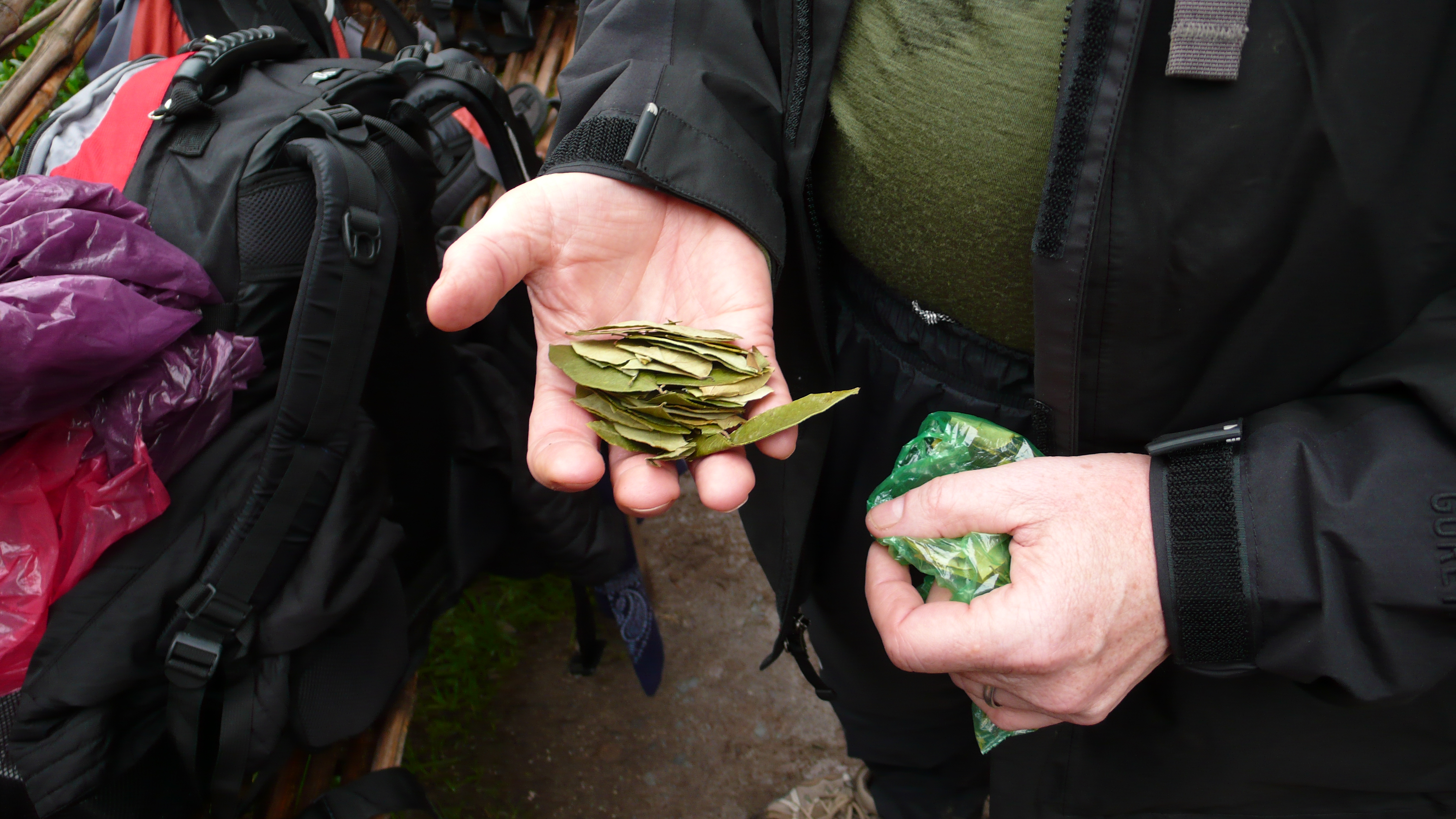
Coca leaves to chew on the tough hike ahead.

The INHL Team about to embark on the adventure of a lifetime!

Main checkpoint for the Inca Trail, getting our passports and tickets stamped at Kilometer 82-Piskacucho.
We arrived at the checkpoint before 7:30am, and even beat the government official to his station. The gate at the bridge over the Urubamba was open, but we only waited a few minutes before the official appeared. Rain had begun to come down by the time our passports and entrance tickets were stamped. Then, with a deep breath and a couple of mandatory photos, we stepped onto the bridge across the Urubamba River and the INHL Inca Trail trek to Machu Picchu actually began!

Etzold Passport Stamps (page 9): Kilometro 82 and Wayllabamba Checkpoints on the Inca Trail

Dave at the bridge over the Urubamba River…where the Inca Trail begins!

View back at Kilometer 82 Checkpoint, the Bridge and the beginning of the Inca Trail.
For the first hour or so the rain alternated between drizzle and steady downpour. It was a good time for us to put on our complete rain suits and get used to the “on-off” process as we hiked at a good clip. The trail was gently ascending along the west side of the Urubamba River which gradually fell away from us as we climbed higher. Shortly, we walked through the first of many trail-side hamlets we’d encounter on that first day. These were usually set up with a rest station of sort for hikers and some kind of display/sales counter for bottled drinks and trail snacks, which the occupants of the hamlet had packed up to their homes to sell to the many tourists that come trekking through each day. This wasn’t their main source of income, as they were all herdsmen and farmers of the patches of fertile ground scattered up the flanks of the steep mountains around us, but it was good supplemental income for the women to earn during the day as the men worked the fields and flocks high above.

One of several hamlets along the first day’s section of the trail.
The Peru government ministry in charge of the Inca Trail and other cultural heritage sites has limited the access to the trail to no more than 500 person per day. Access is allowed by ticket and those must be purchased in advance for a day certain. That might sound like a lot of people on the trail, and it would be if we were all crammed in a gymnasium together. But, it only represents about 150-170 tourist hikers who have the support of a much larger group of porters, cooks and guides (the ratio is about 1 tourist to 3 porter/guides). However, those 150-170 hikers do not start the trek at the same time (ours started at 7:30am for instance) and we met other groups later on who didn’t begin until 10:30am that first morning. Also, the porters don’t hike with their clients, they are amazingly tuned to the high altitude and have incredible carrying capacity. Each morning after striking and packing up camp, they rush off in a group up the trail to set up our lunch stop and have a hot multi-course meal ready for us in a tent with a dining table and chairs all set up! We’ll talk about the food they serve later! Yum! Then, after lunch, the hikers take off and the porters take the lunch setup down, pack it all up and quickly pass us on their way to the evening’s camp site. The process is repeated each day. For this, in Llama Path’s case where their porters all have red rain suits and packs, they have earned the nickname “The Red Army”…here’s to the Red Army!

Even the “Red Army” takes occasional rests…

The trail rises…up, up…always up!
Back on the trail, we start to notice that we pass and are passed by various groups of hikers. As that first day goes on we start to recognize the separate groups and, then, to recognize individual hikers (especially those who have made eye contact and said “hello” in whatever language they speak). Slowly, a common ground is being formed among that day’s group of hikers. Whereas, we might say “Ah, yes, there go those Argentine women who are always chatting”, they might just be saying “Look, there are those surly old American men again”! No matter, first impressions are almost always wrong, thankfully! The point is, and this began to sink in soon after the first re-encounters, we were all here for a purpose…on a mission together…which could be called a pilgrimage. Thus, this modern pilgrimage to an ancient spiritual site, attended by a host of strangers immersed in the routine of traveling, feeding and housing themselves along the route to our final destination, was as close an analogy to the classic Canterbury Tale by Geoffrey Chaucer as I had ever seen! Intertwined among this group of pilgrims should be tales to rival that classic of English Literature…and we will explore some of them here, later: The Flip Flop Man and Toby Tale, Cyril the Rugby Tale, Francesca’s Tale, Malina’s Tale, Chuck the Newly-Wed Tale, Julian’s Tale, and of course our own tales….the Doctor’s Tale, the Dean’s Tale and the Broker’s Tale! We met sound engineers from the UK who worked with an up and coming group called the “Kings of Leon“. There were Australians from Sydney, Argentines from Buenos Aires, Americans from Denver and Brits from Manchester. Each tale grew deeper and more interesting the more often we interacted with our co-travelers, and we had many opportunities to visit on our 45-kilometer trek through the Andes Mountains. The rest stops are numerous as you ascend consecutive 13,000-foot mountain passes!

Building community along the trail with our fellow pilgrims….
The opportunity to turn an initial glance and “hello” in to a full-blown conversation a day or so later is a remarkable gift of community building within this species of ours. The common ground was the challenge of the trek we were sharing, this pilgrimage to a place of mystery and awe…which each of us held in front of us as a lamp guiding and encouraging our weary steps. The lubrication that loosened our tongues was the shared pain and strain, and the corresponding awe at the beauty and majesty of that ancient path to our final goal.
The range in age of the travelers was remarkable. For a day or so, we thought that we were the three oldest on the trek, at 55. But, climbing Runkurakay Pass on Day 3, we met Chuck from Denver and his new wife who were 60 and 51 respectively. Their matching black cowboy hats gave them away as Americans, and I jumped at the chance to strike up a conversation when we had the opportunity during a short rest. The rest of our fellow travelers were mostly (85%) in their 20’s and early 30’s. Surprisingly, it seemed that the majority of us were women! Over 60% we estimated…making a statement of some kind, certainly!
A good half-hour break in the steady ascent that first day came at an overlook high above our first major Inca ruin: Llactapata. This administrative compound and fortress was located at the confluence of the Urubamba River and the smaller Cusichaca River, which we will follow later in the day up to our camp in Wayllabamba at 3,000 meters elevation. The location the Inca chose for this fortress was a strategic and religious pilgrimage site along the historic Inca Trail to Machu Picchu, and was located at the intersection of three valleys, forcing travelers naturally through its portals. Julian Perez, our guide, gave us an excellent first lecture on the significance of the site and the use of the Inca trail system in building the Empire six hundred years ago.

Llactapata ruins at the confluence of three major valleys.

Detail of Llactapata

Bromeliads covering the rocks on a section of trail uphill from Llactapata

We called this the “Bill Gates’ Inca Trail Retreat”…a farmhouse with a nice balcony along the trail!

We pause for a rest with some of our fellow travelers at “Bill Gates’ Retreat”…

Rain and mud became our constant companion…welcome to the “Rainy Season”!
Lunch came when we needed it most, during another drenching downpour. The dry shelter of the tent and the table and chairs set up for our meal gave us a renewed spirit to tackle the trail. The food, served in multiple courses was wholesome and delicious, presented in beautiful style with the requisite coca tea and other liquid refreshments such as coffee and hot chocolate. It was a good thing!

Beautiful lunch served out of the rain….

Inca Trail map….”Can you see where we are?”
A few hours later, and past another couple of trail-side hamlets and what I called the “Escaleras del Diablo” (which turned out later to be just a hint of things to come!), we arrived at our first night’s camp site in the larger village of Wayllabamba. The tents were already set up, the dining tent ready, and all we had to do was unload our packs in the tents and relax for a while before tea time at 5:00pm.

First night’s campsite in Wayllabamba, with our guide Julian and a friendly rooster! The mess tent is to the right. We’re only at 3,000 meters (9,842 feet) and have a long way to go tomorrow!
Chris and I decided to check out the village and a prominent ruin (a “tambo” visible just above the camp site). Jim stayed back in camp as we ventured out for a look around.

The “tambo” at Wayllabamba above our first campsite.
Just above our camp site was what could only be called a “town center”, where several footpaths met and there was a store with a blue hand-painted sign “super market-visa and master card accepted” above the service window on the lintel! I inquired about beer, and the lady told me it was 10 soles ($3 American), I felt taken advantage of until her husband hauled out the huge glass liter bottle of local brew! We promised we’d be back to pick it up later, on our return from our walk, when we’d appreciate it!

David at sign post in Wayllabamba

The “Supermarket” in Wayllabamba’s Town Center!
The “tambo” turned out to be next to the soccer field…probably one of the highest municipal soccer fields in the world, where two teams were going at it in a pitched rivalry! I could barely hike along these trails, and these young men were racing around kicking a soccer ball at top speed! From the ruins, Chris and I finally got a glimpse of the snow-capped peak Veronica far off and high…framed by the walls of the valley through which we had just ascended that day: a 12-kilometer distance and a mere 280 meters higher than when we began the day! I was humbled by the thought of what lay ahead as I contemplated that view of Mount Veronica!

High-altitude soccer game….

View down-valley from Wayllabamba and Mount Veronica in distance.

Detail of Mount Veronica’s snow-capped peak…

The INHL and Llama Path Inca Trail Team at the end of Day One!

Pretty wonderful article, very useful information. Never imagined I would find the information I would like in this article. I have been hunting throughout the net for a while now and was starting to get irritated. Thankfully, I came onto your page and received exactly what I had been struggling to find.
Thank you! Please enjoy the other 17 posts…I think it tells an engaging story, if I do say so myself! I’m still amazed with the experience we had. If you can do it…go!
Very kind. I guess that old English Major of mine finally came in handy! Check out the other 17 posts, they tell an interesting story of the genesis of this team and our love of adventure. If you are even thinking about this adventure, don’t hesitate…it’s a life-changing, “bucket list” kind of experience!
I’m so glad to have found your web page. My pal mentioned it to me before, yet never got around to checking it out until now. I must express, I’m floored. I really enjoyed reading through your posts and will absolutely be back to get more.
Thank you Sue…truly a labor of love, what an adventure! David
Hi, I applaud your blog for informing people, very interesting article, keep up it coming 🙂
You can follow the most recent posts to the Blog at
http://www.davetzold.wordpress.com
DFE
Hi Dave thanks very much for your lovely blog and photographs. I’m going to Peru with my Mom who is 84 (she will do other travelling while I do some hiking). We’re travelling from Cape Town and I don’t know anyone else who can hike at this time, but judging by what you say I’ll make some friends in the process of doing the hike. It sounds as if joining a group run by Llama Path is my best bet. Do you know any way of linking up with like-minded folk who might want to hike at that time (around the 28 June). Just thought it was worth asking 🙂 Thanks, Ingrid 53-year old South African
Hi Dave
Am writing now that we’ve been to Peru as I’m looking again at your blog. I didn’t do the Inca Trail, just travelled by train with my mother, but we had a wonderful time. What a beautiful country and such friendly people. Everyone knows about South Africa now because of the World Cup soccer.
I’m writing because now I REALLY would love to do the hike, even if it takes a few years of organising and saving to get back there. I just experienced some real terrifying moments, looking down at the precipitous drops and wondered, if you could let me know whether you think someone with an occasional fear of heights could manage the Trail? My fears are worst when the path is narrow and there are sheer drops down. Are there lots of places like that on the hike? How did other people cope, or was everyone you met quite relaxed about heights?
many thanks
Ingrid
Ingrid, Thank you for the note. I had a colleague with us on our trek who had a fear of heights as well and he made it through just fine. The trail is well built and though there are places where the view is grand of the deep Urubamba RIver Valley, you should have no trouble. Good luck. DFE
Hi Dave, Much appreciate your answer. Hope you’re planning other adventures and enjoy your 4th July.
Warm regards
Ingrid
Thanks so much for this blog…it’s well written and informative. I love everything about it and can’t thank you enough as I prepare (with 5 other women) to hike the trail this June.
One of the most remarkable experiences of my life. Thank you for the compliment…a degree in English Lit wasn’t wasted!